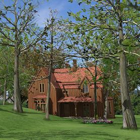
The JPCA has unveiled an architectural rendering of what the St. Saviour’s Church and Parsonage will look like after both they and the historic grounds upon which they sit are saved and fully restored. The rendering, by Marcelo Orihuela of Todocad (www.todocad.com), is based on the original design of the church. It is the only known representation of the buildings that shows them in their previous state and in full color. St. Saviour’s was covered in gray asphalt sheeting from the 1950s through the mid-1990s. In 1997, layers of white aluminum siding were added.
Last year, when the demolition of the church commenced, removal of these layers revealed that most of the original board-and-batten structure, designed in 1847 by master architect, Richard Upjohn, was still intact underneath. Luckily, JPCA was able to have the site shut down before further damage was done. There currently are portions of the original church structure that are exposed. This underlying structure was referred to in decades-old newspaper accounts as being made of “redwood,” and the wood revealed does have a reddish hue. Therefore, this is the color upon which the rendering was based.
The landscape is that of a rolling hill containing 185 trees (yes, we counted each one individually).
As the city moves toward implementing Mayor Bloomberg’s plan to have a park within 10 minutes walking distance of every city resident, the Juniper Park Civic Association urges them to consider that this area was left out. A good way for the mayor and city council to spend some of this year’s $4.4 billion budget surplus would be to purchase this much needed green space for the people who live and work here.
The status of the church has been in limbo for more than a year. The community wants this property saved, the buildings turned into a museum and community center, and the grounds preserved as a public park. The developer needs a zoning change from manufacturing to residential in order to build as planned; this has remained stalled in City Planning since 2005.
Meanwhile, the city has been selling off what remains of its vacant lots – in some cases giving them away – in order that high-density housing will be built to accommodate an expected population increase. The city’s Brooklyn sites are clustered in the neighborhoods of Crown Heights and Flatbush, where Maspeth Development, LLC, the owner of St. Saviour’s, owns many of its other properties.
If buying the property is not an economically feasible thing for the city to do, then a land swap would be the perfect solution for all parties:
– The developer would be able to build what he wants (or larger) without a rezoning headache
– The community will save its landmark church and grounds and get a much needed park in Maspeth.
– The mayor will get the denser housing he wants in an area that actually needs it
– City planning will not be put in the embarrassing situation of having to explain how the same lumber yard that prevents the building of new housing in a manufacturing zone (because of the danger of fire), does not pose the same problem in a residential zone, and also, why putting new housing along a newly designated, heavily traveled, extremely polluted truck route is a good idea.
In addition:
A good portion of West Maspeth was intentionally left out of the recently designated Industrial Business Zone in anticipation of gradual rezoning to allow for new housing.
Before that happens, some infrastructure improvements need to be put in place. The church should be a central part of that plan.
The Maspeth rail station, across the street from the church, could be reopened to provide improved public transportation to the area. It would also bring tourists from outside the community to the museum.
There are empty storefronts in the immediate area that would likely reopen if St. Saviour’s were to become a park. The park would become the center of a revitalized neighborhood and raise property values.
Opening the grounds of St. Saviour’s to the community would fill one of the gaps in the Mayor’s 2030 plan to have every city resident within 10 minutes walking distance of a city park.
This plan was sent to the Mayor’s office. We look forward to receiving a positive response from the Bloomberg administration and to working with them to make this dream a reality for Maspeth.
One final note: JPCA previously mentioned that the Buckeye jet fuel pipeline, which runs between Rust Street and the freight tracks just west of the property, presents a potential hazard to the community, should there ever be an accident. This same pipeline was recently revealed to have been targeted by terrorists at its terminus near Kennedy airport. Introducing more housing along this pipeline does not make much sense in this day and age.