The proposed rezoning of Middle Village, Maspeth and Glendale initiated by the Juniper Park Civic Association in 2004 is finally completed. The JPCA started the project at a meeting at Trinity Lutheran Church in Middle Village and this writer still has a list of the volunteers who participated. We went door to door with lists of the housing stock in the neighborhood. Each house was viewed and changes from the original plans were documented at each address. It was tedious work but necessary, according to John Young, Director of City Planning. In effect though, volunteers did the City Planning Department’s job, pro bono, because it was stated that City Planning didn’t have the personnel to do the work.
We feel the Bloomberg Administration deliberately stalled the project so that the building frenzy could go on, focused on Mayor Bloomberg’s goal of building “affordable housing.” We can’t change the damage already done as we waited for these proposed changes but we can go forward with the knowledge of what future building development possibilities can be.
Formal public review of the proposal began on April 20, 2009 with the Department of City Planning’s Certification of the Uniform Land Use Review (ULURP) application. The proposed project will end up in the NYC Council approximately 140 days after June 29, 2009 when the Community Board 5 Review process must be completed. The following is the Rezoning Project Summary as stated by the Department of City Planning.
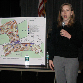
The Department of City Planning proposes the rezoning of roughly 300 blocks in three neighborhoods in western-central Queens. Middle Village, Glendale and Maspeth. For study purposes this very large area has been divided into four smaller sections.
The first section is located in eastern Glendale and is bounded by Woodhaven Boulevard, 76th Avenue, 88th Street, 77th Avenue, 80th Street and Cooper Avenue. The second section is located in western Glendale and is bounded by the Long Island Railroad, 70th Avenue, 69th Place, Myrtle Avenue, 73rd Street and Mt. Carmel Cemetery. The third section is located in Maspeth and is bounded by 59th Street, Mt. Olivet Cemetery, the Queens-Midtown Expressway and Admiral Avenue. The fourth section is locate in Middle Village and is bounded by the Queens-Midtown Expressway, Woodhaven Boulevard, Mt. Olivet Cemetery, 80th Street, Juniper Boulevard and Lutheran Avenue.
The Middle Village-Glendale-Maspeth rezoning study builds upon recently adopted lower-density and contextual rezonings in portions of these neighborhoods, including the Middle Village-Glendale rezoning (March 2006), Maspeth -Woodside rezoning (May 2006), and the Middle Village Follow-up rezoning (August 2006) as well as the rezoning of a portion of Middle Village in 1994.
The Department of City Planning implemented these rezonings in response to requests from Community Board 5, area residents, local elected officials and civic groups who expressed concerns that the development occurring in these neighborhoods was out of character with established development patterns and built contexts.
The Middle Village-Glendale-Maspeth rezoning will extend similar protection from out of character development to portions of these neighborhoods which had not been covered by previous actions. In the current rezoning area, much of the existing zoning has been unchanged since 1961, and the existing R3-2, R4 and R5 districts allow a variety of building envelopes and housing types which can be inconsistent with prevailing scale, density and built character. Small portions of the rezoning area are zoned for industrial uses M1-1 and M1-4D. Within these areas certain blocks are developed predominantly with residential buildings.
Two types of zoning changes are
recommended: Lower Density/Contextual Zoning Changes: Protect the character of these neighborhoods and reinforce the established built form by replacing existing zoning on roughly 300 blocks (R3-2, R4, R4B, R5,, M1-1 and M1-4) with lower density and or contextual zoning districts where appropriate (R3A, R4-1, R4!, R4B, R5B and R51)
Commercial Overlay Changes: Removing entirely or reducing the depths of commercial overlay zones where appropriate to prevent commercial intrusion on residential blocks. Adding commercial overlays were appropriate in order to reflect current land uses and encourage retail continuity along prime shopping streets.