How the Great Borough of Queens, New York City, Composed of Sixty Former Villages, Changed the Names of Most of Its Streets and Gave New Numbers to All of Its Houses
From The American City, February 1928.
What would happen in an American city of the size of Boston, if the authorities should pass an ordinance changing the names of most of the streets and assigning new numbers to all of the houses? It would, perhaps, precipitate a riot, or even necessitate a special act of the legislature to put the new system into effect; and yet such a change was actually brought about in the borough of Queens, which contains a population larger than that of Boston, and covers nearly as much land as does the city of Philadelphia.
The borough of Queens with its 117 square miles of land area is the largest in extent of the five boroughs comprising the city of New York. Queens, with its million-odd inhabitants also surpasses the other boroughs in its rapidity of growth, as is shown by its five-fold increase in population, and its thirteen-fold increase in the assessable value of its realty, to a present total of $1,850,000,000 during the past 25 years.
The problem of naming the streets and numbering the houses was made more difficult by the fact that the territory was formerly occupied by about 60 villages, each having its own separate system of street names and house numbers. These villages were connected by country roads. Only in two sections was there continuity in the street plan.
In 1911, when Maurice E. Connolly was first elected President of Queens Borough, he directed the Topographical Bureau to make a thorough study of the problem of connecting these divergent street systems, of widening and straightening the old highways, and of assigning to the streets appropriate names, such as would be a clue to the portion of the borough in which the highway was located. Duplication of street names was also had become by that time a serious source of annoyance, particularly to the post office authorities. When the various villages included within Queens Borough were separate communities, it did not matter particularly whether or not there was a Main Street in Jamaica, and another Main Street in Flushing. By 1911, when these various subdivisions of the borough were being mapped together into one street system, it was clear that some plan must be developed to substitute new names for all but one of the ten different highways called Main Street in as many different parts of the borough; or that would reduce by 29 the 30-odd streets and avenues named after President Washington.
In working out a logical system that would be descriptive of the locality in which the street was situated, and at the same time would avoid such repetitions of names, the Topographical Bureau was confronted with the necessity of changing the names of about 75 percent of all streets.
The change consisted in the adoption of a system of numbering in which the term “Avenue” was used to designate highways running east and west, while the word “Street” was employed for those going north and south, or at right angles to the avenues. Streets were numbered consecutively, starting with First Street and ending with 271st Street. The avenues were also numbered serially, starting with 1st Avenue and ending with 162nd Avenue.
Overcoming Opposition of Old Time Residents
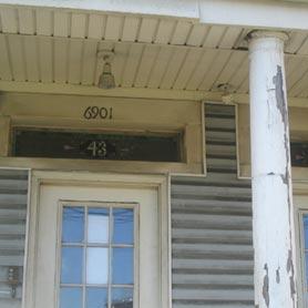
When such a radical change was first proposed, it naturally met with much opposition. Most of the old-time residents of the 60-odd villages and towns were horrified. Some of the streets had been named as long ago as Boston’s Common, or Philadelphia’s Broad Street. Hence, streets and houses were at first renamed or renumbered on paper only. The next step was to provide street signs with the new names for the outlying portions of the borough, which were then being developed, and to assign house numbers for such developments in accordance with the new system. The old built-up sections were avoided, until they became surrounded with newly built-up areas, containing streets showing the new names at the corners, and houses numbered in accordance with the modern system. All the new buildings that were erected within the older sections, such as Jamaica and Flushing, were also provided with the new numbers, and these finally so altered the character of the former villages that the evolution from the old to the new system at last became complete. Today, comparatively few of the older buildings carry the former numbers, and these are rapidly being demolished.
One reason for adopting the new system is that it enables the stranger to visualize the location of any street or avenue by its number, a low number indicating that a street is in the western portion of the borough, while a number in the 200’s would be to the east of Hollis or Flushing. Similarly, in the case of the avenues, a low-numbered avenue would be in the northern part of the borough, while a number above 100 would be south of the Atlantic Avenue Division of the Long Island Railroad, or in the vicinity of Jamaica Bay. In the Rockaways the system differs in that the lowest-numbered street is adjacent to the Nassau County line; while the numbers increase consecutively, until the highest number is reached at Rockaway Point, near the western end of the peninsula. To avoid confusion with the system in the main portion of the borough, the numbered streets in Rockaway are preceded by the word “Beach,” an abbreviation for Rockaway Beach; thus we have Beach 2nd Street in Far Rockaway; Beach 75th Street in Hammels, Beach 116th Street in Rockaway Park, etc.
In the welding-together of many communities, such as Flushing, Corona, Jamaica, Long Island City, etc., each having its own street system, into one homogenous whole, it frequently happens, where two different street systems come together, that there is found to be one or more short streets, spaced between two consecutively numbered streets, that must be given a name. Thus, if a single street should fall between 20th and 21st Streets, it would be called 20th Place; if two streets should be left in this way, the first would be designated as 20th Place, and the second as 20th Lane. A similar system is used in the case of avenues, or highways running east and west; but in this instance, in order to avoid confusion, the terms, “Road” and “Drive” are employed instead of “Place” and “Lane.” In some localities short curved streets have also been projected, as in Forest Hills, Douglaston, etc.; these are called “Terraces” or “Crescents.”
Again, there are important traffic arteries, the names of which have long since become household words in the borough, such as Jericho Turnpike and the Merrick Road. Many of these thoroughfares are winding, or extend diagonally across the numbered streets and avenues, so that it is impossible to designate them by numbers. Some have historic names, or are identified with the names of former villages in the borough, such as Fresh Pond Road or Jamaica Avenue. Others have been named after the founder of a great industry, like Steinway Avenue. These old names have been retained whenever it has been possible to do so without conflicting with the system. Where a thoroughfare is sufficiently broad or important, it is called a “Boulevard,” and boulevards can run either north or south, like the streets; or east and west like the avenues, or can cut diagonally across both streets and avenues.
Street names can be amended only by a resolution of the Board of Aldermen, according to Section 50 of the Greater New York Revised Charter, between the first of December in any year and the first of May in the next following year.
The present system of numbering streets throughout Queens Borough was given official recognition in 1915, when the Richmond Hill map was approved by the Board of Aldermen. This was followed by the Flushing and Far Rockaway maps in 1916; the Bayside map in 1917; Jamaica and Queens Village in 1919; and by the approval of new street names for Rockaway Beach in 1920; Corona and Hollis in 1921 and 1922; Ridgewood, Maspeth and Long Island City in 1925; and Springfield and the southerly portion of the borough in 1926.
The new system of house numbering in the borough was first applied to the Ridgewood section, as shown on a map proposed by the Topographical Bureau in 1908. This was because Ridgewood, owing to its location with reference to Brooklyn, and to the rapid-transit facilities, already in use at that time, was the portion of the borough that was first intensively developed, and which assimilated the first wave of immigration that was later spread out over the entire borough. It was not, however, until three years later, in 1911, that significant progress was made in the task of renumbering houses. A further impetus was given in 1915, when the Richmond Hill map was completed; and by 1925, when the system had been extended to Long Island City, the new numbers had come into general use.
Cooperation from the Building Department
One force that materially helped in carrying out this great undertaking was the support of the Borough Building Department, in withholding permits for new buildings until the builders had first obtained the new numbers from the Topographical Bureau. Great assistance was also rendered by the public utility corporations, such as the telephone and gas companies, in withholding service until the applicant had first obtained his proper house number. The local newspapers also, without regard to politics, rendered hearty support to the change; and of course the postal authorities were in full accord with the new system, and in numerous instances notified householders that they would not be responsible for the delivery of mail unless the owner should put up the proper number. Dealers in house number plates sprang up, as it were, overnight, and by going about from house to house soliciting orders gave further impetus to the adoption of the new numbers. At one time there were so many dealers in the field, soliciting orders for house number plates, that their activities had to be curbed by the Topographical Bureau as being oppressive.
The motive back of cooperation on the part of public and of quasi-public corporations and societies, which the Topographical Bureau has received, in extending the new system of street and house numbering throughout the borough, may be regarded as due in part to public spirit, and in part to enlightened self-interest. For example, it is of great advantage to the gas, electric light, and telephone corporations that there should be, for instance, only one No. 1 Washington Street, instead of thirty.
One illustration will show the value of the new system to the stranger – and a resident of one of the former villages in Queens may be as much of a stranger in another part of the borough as would be a newcomer from a western state. Occasionally the Topographical Bureau receives a telephone request from a newspaper man asking the number of a street which corresponds to a certain former name. Perhaps the editors had been notified of occurrences having news value, near the corner of, say, “Washington and Grove Streets,” names which when translated to signify the corner of 160th Street and 90th Avenue, enabled the reporter to spot the place as in the Jamaica District, easily reached by the Long Island Railroad.
Signs Indicate Street Numbers and House Numbers
In order that a house number may be of greatest value in indicating the location of its premises, the number is divided into two parts, separated by a dash, in which the first part of the number is the same as that of the nearest cross street or avenue, intersecting the avenue or street to the west or north, and the second part of the number represents the distance, as expressed in lot intervals, between such corner and the house, a number being assigned for each 20-foot space. Odd numbers are assigned to buildings on the north sides of avenues and the east sides of streets, while even numbers are used for houses on the south sides of avenues and the west sides of streets; in which the term “street” is used to designate all thoroughfares running north and south, and “avenue” is employed for thoroughfares running east to west or at right angles to the streets.
For instance, if a house is on 30th Avenue, between 25th and 26th Streets, the first part of the number would be 25. If the house is on the north side of 30th Avenue, and is at the corner of 25th Street, the second part of the number would be 02. That is to say, the first mentioned house would be called 25-01 30th Avenue, indicating that it was on 30th Avenue and occupied the lot space adjacent to 25th Street, in the block between 25th and 26th Streets, and was on the north side of the avenue. As another illustration, take the number 125-42 221st Street. Such a house would be situated on 221st Street, in the block between 125th and 126th Avenues, because the first part of the number is 125. It would be on the west side of 221st Street, because 42 is an even number. Dividing 42 by 2, because half of the lots would be on the west side and half would be on the east side of the street, gives 21, the number of lots between the house and 125th Avenue. As a space of 20 feet is allowed for each lot, the distance of the house from 125th Avenue would be 21 x 20, or 420 feet.
That is to say, the number 125-42 221st Street, would be a complete description of the location of a house, and could apply to only one position in the entire borough. Since the number assigned to a house is based entirely on its location, it follows that when houses occupy plots wider than 20 feet it is necessary to skip over one or more numbers.
The value of the numerical system of street and house numbers, like that of the Weather Bureau, cannot readily be estimated in terms of dollars and cents. In expediting and preventing mistakes in the delivery of mail and merchandise, the system has an economic value which is obvious. The number of a house being an index to its location, strangers find their way about with a minimum of effort; physicians, summoned from a distance; reach the bedside of their patients without delay; the work of the Police and Fire Departments is speeded up where the time element is of prime importance. The entire fabric of social and economic life within the borough, as well as its contacts with the outer world, is strengthened by a system of street and house numbers that opens the gates to all.

