The Towns of Newtown, Jamaica, Long Island City and Flushing in Queens County joined the City of New York in 1899. (Oyster Bay, Hempstead, and North Hempstead made up 70% of Queens County until they split off and formed Nassau County, escaping consolidation.)
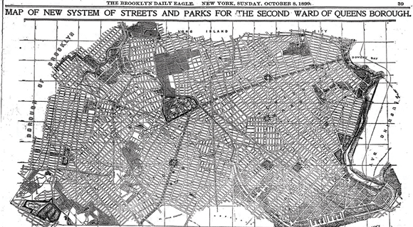
During this time, the Board of Public Improvements developed grand plans for the borough. The map shows the Newtown area, which was at the time known as the Second Ward of Queens. The map is rotated about 90 degrees to the right, so keep this in mind when trying to identify major roads, neighborhoods and landmarks.
The first strange thing you might notice is that there was a canal proposed to flow between Newtown Creek and Flushing Creek. This was to keep the creek water from becoming stagnant, to drain the many marshes in the area to make them developable and to facilitate shipping further inland. As you are aware, this plan never came to fruition.
The next thing that jumps out is that there was a huge park planned for Maspeth, just north of Grand Avenue. At the time, this was the site of the Maurice Woods. The deal never happened, and the real estate was sold off to developers. This is now the area of the Ridgewood Plateau. There were also many other smaller parks planned throughout our area that were never built.
There were some neighborhood names back in 1899 that have fallen into disuse. You’ll notice that adding the word “heights” after the name of an established neighborhood was all the rage. Maspeth Heights, Newtown Heights, Nassau Heights, Woodside Heights, Ridgewood Heights, Wyckoff Heights, Corona Heights and Hyatt Heights all appear on the map. Perhaps people wanted to think of where they lived as being “a step above” the more established well-traveled areas.
Then there are the really antiquated neighborhood names like Louona Park, Locust Grove, Trains Meadow, St. James Park, Berlinville and Charlotteville. It’s interesting and a bit sad to think about how these names came about, then fell out of favor and got wiped from maps and residents’ memories over the decades.
This map predates both the NYC subway and Juniper Valley Park. Middle Village had a sizable swamp back then, but there must have been plans to drain and fill it in because a street grid appears across the entire area where the peat bog had been at the time.
Another thing that seems odd was the liberal use of traffic circles at major intersections. Can you imagine the resultant car clusters at Fresh Pond Road and Metropolitan Avenue or Grand and Flushing Avenues with traffic circles in play?
Most of the Gay Nineties grand plans for Queens thankfully never happened. Some ideas definitely belong in the dustbin of history!