How people traveled before the turnpike
From An historical sketch, of ancient agriculture, stock breeding and manufactures in Queens County by Henry Onderdonk, 1867.
In order to illustrate the difficulty of traveling on Long Island in early times before much attention was given to the improvement of roads, we give some “observations” made by Reverend N. Huntting, on his journey from East Hampton to Newtown at the beginning of the last (18th) century. They were noted down in a guidebook that he might not miss his way in traveling.
• Beyond Southhampton, about 16 miles, being about 3 or 4 miles from the mill, going over a little brook, just beyond a little wooden causey, and then two paths; leave the right path which goes away to the marsh, and take the left-hand path.
• Just over the river by Parker's Fulling-mill leave the right-hand beaten road (which goes to Southold) and take a little and blind foot on the left hand.
• A little beyond Coram house leave the right-hand path which goes to Setauket, and take a left hand small path by the corner of the field.
• A mile beyond Huntington, take the left-hand path; about 2 miles further you come to a new built house and an old one on the left hand, and the mile further take the left-hand path.
• Going on to Hempstead plain take the right hand of the two first pants if you would go the back way and leave Hempstead town; but if you would go through Hempstead, then take the right of the two next paths.
• Going the backside of Hempstead plain towards Jamaica, being got past Hope Williams' about 4 miles, entering on another part of the plain, and being come at one house in the corner of a fence with the well before the door, take the left-hand Path though it be but blind, leaving the plainest path going to houses on the right.
• Going from Jamaica to Newtown, being a little past the last house in Jamaica, take the left-hand.
• Going from Newtown to Jamaica, about 2 miles from Newtown by field, take the right-hand path.
Our ancestors, doubtless, undervalued the utility of good roads. In 1702 the highway from Jamaica to New York was so bad as to become the subject of general complaint. In 1808 when the turnpike was projected on this line, the farmers were so opposed to it as to hold an indignation meeting.
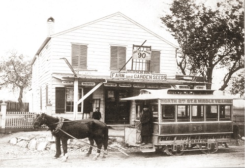
Horse Cars were small passenger cars that usually held from 22 to 30 passengers and were pulled along iron or steel tracks by a horse. The car weighed about two tons and the passengers up to three tons. The horse was expected to be able to pull this load at 3 to 5 miles per hour. Operating a horse car railroad was relatively expensive as it required buying horses and keeping them in a stable when they were not working. Stable hands were necessary to clean the stable and feed the horses. Homes in the vicinity of a horse car stable on a hot summer day were exposed to strong odors from the piles of manure outside the stable and also to flies. The manure was collected and sold to fertilizer dealers. In 1867, horse cars started operating from the ferry landings in Williamsburgh to Middle Village along Metropolitan Avenue. Initially they went as far as where the first gate to Lutheran Cemetery was on the south side of Metropolitan Avenue. Then later the service was extended to about 70th Street, and then in 1882 a single track was extended to St. John's Cemetery at Dry Harbor Road (80th Street). About 1896 electric trolley cars replaced the horse cars running to Middle Village as trolley cars were less expensive to operate and were much faster. In Manhattan the last horse car railroad remained in operation until about 1910. About 1917 the electric trolley cars on Metropolitan Avenue extended the service to Jamaica Avenue. About 1950 the electric trolley cars on Metropolitan Avenue were replaced by buses.
80th Street (Dry Harbor Road) was laid out in 1780 as a wagon path by the Township of Newtown from what is now Woodhaven Boulevard to the cluster of farms at Dry Harbor, namely John Morrell, Abraham Morrell, Henry Forbell, Christopher Remsen and Johannes Bartlefolk. It replaced an earlier trail. It ended at approximately where Myrtle Avenue and 81st Street in Glendale are today. Eventually the road continued south thru the lands of Thomas Betts and Stephen Lott to the Brooklyn-Jamaica Ferry Road (now Jamaica Avenue). William Forbell, son of Henry Forbell, in the 1800's had a farm on the east side of the road in what is now Glendale, and he took his farm produce by horse and wagon south on the road to the Brooklyn-Jamaica Ferry Road and then by another road south to the boat landing at Plunders Neck in Jamaica Bay where he loaded his produce on board his boat and sailed to the Catherine Street Market on the East River in Manhattan. In 1800 there was a public well on the corner of Cooper Avenue and Dry Harbar Road for the use of travellers to water their horses and also for drinking water for themselves. In May, 1925 the names of many streets in Queens County were changed to numbers. A section of the road in Middle Village eventually became 80th Street.


