The first map of Long Island on record was made by Adrian Block 1614. Because it is relatively flat, Long Island had no great rivers or falls that could be harnessed to provide power to drive machinery. So the first 150 years, its largest industry was farming. L. I. supplied the food to the growing population of Manhattan.
On our end of L. I., the farmers took their fruits and vegetables by horse and wagon to the Maspeth Town Dock to be loaded on shallow market boats headed for Manhattan. On eastern L. I., Brookhaven had a fleet of more than 100 ships. It was the building of these vessels, whalers and later swift passenger sloops for the trip to Manhattan that led to the growth of shipyards at Port Jefferson, Setauket and other places on the island. The sloops sailed to Manhattan with cords of wood, wheat, and farm produce. They didn’t come home empty but returned with an odd cargo. It was the street and stable sweepings (manure), ash and bone of Manhattan, all needed as fertilizer.
Whaling in Greenpoint
The next big industry was the whaling business in Sag Harbor and Greenpoint. It became Long Island’s most prominent industry. There was a great demand for lamp fuel between 1820 and 1850. Sag Harbor maintained a fleet that once numbered 63 whaling vessels. Hard times came when gold was discovered in California in 1849. Whale oil profits and prosperous voyages were forgotten when gold bewitched young and old. Ships docking at San Francisco to refurbish supplies were quickly deserted as the crew made a rush for the gold fields. Reduced manpower, as well as a shortage of whales caused by 50 years of plundering were the first signs of a dying industry. The final blow was the discovery of oil and the subsequent development of kerosene, a far better fuel than whale oil. Sag Harbor became a sleepy village once the last whaling ship sailed in 1871.
Almost simultaneously, the industry that most directly ended the whaling days began its development along Newtown Creek on the western tip of Long Island. Several oil refineries were established there on both the Greenpoint and Maspeth shorelines to process the newly-discovered crude oil then being pumped from the first oil wells in Pennsylvania. Then sparsely populated, this section became a repository for industries that were considered “smelly.”
Maspeth was a small community near the Creek whose major importance during Colonial times was its Town Dock. During the Revolutionary War Maspeth had only 12 houses. There was little increase until about 1800. By 1852 there were 56 houses in town. By 1875 there were 1449 residents listed on the Maspeth census. Residents of Middle Village were included in the Maspeth census.
One of the first of the unsightly factories was the Eagle Fireworks Co. of Williamsburg, founded by Philip Licht in 1856. There were numerous fires and explosions, but the business prospered. During the Civil War, Licht made signal rockets for the Union Army.
Paint. and varnish and chemical plants followed. Blackwell & Co. refined turpentine. Cord Meyer colored bone carbon black for use as carriage paint, since all buggies and carriages then were a sombre black. In 1866, the Nichols Acid Works began making sulphuric acid on the creek’s shoreline.
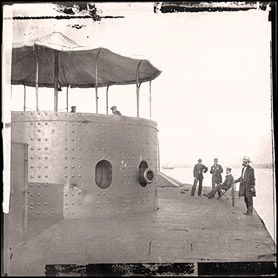
Civil War Ironclad Built on Creek
Near Newtown was a great shipbuilding town called Greenpoint. This community overlooked the East River. At West and Calyer Street was a shipyard which gave birth to one of the great revolutionary vessels of the world, the Monitor. Thomas Fitch Rowland was the builder, and in 1861 work was started on this vessel. She was completed in 101 days, launched and towed down the East River. From there she sailed off to Hampton Roads, Virginia, and on to glory by almost sinking the Confederate ironclad, the Merrimac, in one of the most extraordinary conflicts of naval history. It was the first sea battle between ironclad ships. On Forest Avenue and Butler Street., the Eagle Fire Works operation plants were located, operated by Philip Licht. It was here that the time fuses were installed into the shells that were to be used by the Monitor.
Industry Pollutes the Creek
The blight that exists today along the murky waters of Newtown Creek became apparent not many years after industry first established itself there. By 1920 the waterway was referred to as the place “covered with the scum and refuse of vast oil refineries, fertilizer factories, and chemical works along its banks.”
It was once dubbed the “World’s Most Important Waterway,” and “Queens’ Little Mississippi” but years of oil and sewage pollution have reduced Newtown Creek to a dying Bayou. The three mile long inlet, which includes a number of canals into Brooklyn, is a natural border separating Queens and Brooklyn. Before World War II, Newtown Creek was one of the busiest commercial waterways in the country, second only to the Mississippi River in tonnage. Now its waters are often littered with barges transporting oil, metal and garbage.
Colonial Route
It has been the site of much history in the last 350 years. It was the route by which European colonists first reached Maspeth. During the American Revolution, the British hid their ships in the waterway to protect them from attack by the American army. Farmers brought their produce to the Maspeth Town dock on the way to Manhattan. During the Revolutionary War it became a landing place for British supplies.
Richard Newman, regional water engineer for the New York State Department of Environmental Conservation said: No fish would be crazy enough to go into Newtown Creek.