In 1638 Governor Kieft purchased the land near Newtown Creek, and the new Charter of Freedoms and Exemptions, published two years thereafter, providing that “all good inhabitants were allowed to select lands and form colonies” attracted settlers to this neighborhood. Thus, a small band of former residents of the Plymouth colony, under the leadership of the Rev. Francis Doughty, settled in 1642 near the Indian village. In the Indian uprising of the following year, caused by a most barbarous act of the governor, the Mispat settlement, as many others, was laid in ashes and some of the settlers were killed, while others made their escape to the fort on Manhattan Island. After peace was restored several of the planters returned to the place. A new commander, Petrus Stuyvesant, took charge of the Dutch Colonies in 1647, and he employed every means to secure new colonists for the destroyed and deserted plantations.
In 1655 the natives again became restless, and the settlers near Mispat Kill found it necessary for their mutual safety to abandon the exposed dwellings standing upon the several plantations and to remove their families and belongings to a central point, which could be more effectually defended. Thus they formed in the next spring a village upon an island situated in Mispat Kill, for which the Fiscal of New Netherland, Nicasius de Sille, had received a patent. They named the settlement New Arnheim, in honor of the native place of De Sille.
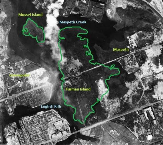
The island was then known as Smith’s Island, after an earlier resident, and its later names were Maspeth Island, Mott’s Island and Furman’s Island. Here they were in a more secure position and the new settlement prospered. Still some of the farmers continued to live upon their plantations. Eldert Engelbertse, residing at an isolated place near the creek, with his wife, and two men employed by him, were murdered in 1659 by three Raritan Indians, who had become acquainted with the fact that there was some wampum in the house.
While the site of New Arnheim, surrounded as it was by water, was well chosen for a place of refuge for a small band of settlers during trouble with the Indians, it was not the proper place for a village. So when in 1660 fourteen Frenchmen with an interpreter came before the governor to petition him for land on which to settle, Stuyvesant took them across the river and selected a plot of land between the Mispat Kill and Noorman’s Kill (the later Bushwick Creek). In doing this he was no doubt guided by a personal interest. His own farm on the Manhattan Island side of the river extended from present Fourth Avenue to the East River shore, and the newly established settlement on the Long Island side was directly opposite his farm, the river flowing between the salt meadows of the two tracts of land. Thus he must have felt more secure from attacks by the Long Island Indians by having this out-post between them and his own farm. However, the land between the two creeks was an ideal location for a village site. Along the line of an old Indian trail a road was laid out in the center of the village plot, which, in course of time, could be extended towards either creek.
To every house-lot in the village was attached the right to a certain part of the common lands or salt meadows. These meadows were taken wherever found, and in the following year the magistrates petitioned for more meadow land for the use of additional settlers, and Governor Stuyvesant ordered the New Arnheim settlement to be broken up, being an obstacle to the growth of the new village of Boswijck (Bushwick), and the island was given to the latter. Boswijck was the name bestowed upon the place by the governor. This grant caused a legal fight, which was carried on for over a century between the towns of Newtown and Bushwick. In 1769 Smith’s Island was ceded to Newtown, and other disputed lands, now forming the Ridgewood section of Queens County, were also decided to be a part of the town of Newtown.