If you travel through western Maspeth (or just look at a map of it), you’ll notice that Maspeth Avenue, originally a colonial road, strangely turns right one long block west of the Rust Street LIRR crossing. This wasn’t always the case, however. Maspeth Avenue once was a rather straight road that connected Brooklyn and Queens via a bridge over Newtown Creek. In April 1836, Garrit Furman laid out and opened an improved Maspeth Avenue to serve as a means of approach to his mansion on Furman's Island, which up to that point had only been accessible from the Brooklyn side by water. The new road ran from the junction of 58th Street and Maurice Avenue westward over marshy ground to the creek shore. The Maspeth Avenue and Toll Bridge Company, also created by Furman, maintained the street. A bridge was built over Newtown Creek and the road was continued on the Brooklyn side and a penny toll was collected on the bridge. Judge Furman watched the building of the road over his land and dedicated a little poem to the workers in his poetry collection, “Rural Hours.” Furman passed away in 1848. In 1850-51, the street was paved with planks, and afterward referred to as “Maspeth Avenue Plank Road”. Farmers and stagecoaches used this route heavily to get to and from the ferry to Manhattan.
In 1875, when the Grand Street Bridge was opened to the south, the Maspeth Avenue toll bridge ceased operations after many years of neglect. The bridge was demolished in 1876 and over the next 6 decades there were numerous calls by townspeople and government officials to build a replacement. In 1894, there was even a court order issued that mandated a new bridge but the defendants – the respective Boards of Supervisors of Queens and Kings Counties – managed to get the judge’s decision overturned, which doomed the prospect of a new span.
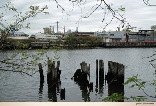
When the US entered WWII, the government mobilized defense production and built a gigantic 100-acre aluminum plant in the marsh on the Queens side of Newtown Creek. This forced Maspeth Avenue to be diverted down along the eastern edge of the facility, where Page Place is today. It was several years after the war’s end when the plant was demolished and the land was apportioned into lots and sold. However, the former route of Maspeth Avenue was not restored. In order to create lots with straight lines, the road was cut through in the opposite direction, and now ends at 48th Street, just south of Maspeth Creek. If you continue down 48th Street, its next intersection is with 58th Road, which was part of the original Maspeth Avenue. The road ends at the bank of the creek. Looking down into the water at this spot you can see some of the wooden remnants of the Maspeth Avenue Bridge, and if you gaze across the creek, you’ll see the anchorage where it connected on the Brooklyn side.
Colonial roads were named after where they led travelers, and Maspeth Avenue brought those coming from the west right into the heart of town. In Brooklyn, Maspeth Avenue starts at Humboldt Street. The road originally connected Brooklyn with Furman Island, which later became fused with Maspeth via landfill in the early 20th century. In the 19th century, Maspeth Avenue was called a “highway”, and although it is a well-traveled road today, it would be even more so if it hadn't lost its bridge connecting Kings and Queens Counties.